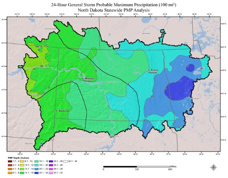
Results of this analysis reflect the current standard of practice used for defining PMP, including comprehensive storm analyses procedures, extensive use of geographic information systems (GIS), explicit quantification of orographic effects, updated maximum dew point for storm maximization, development of snow water equivalent (SWE) and temperature time series climatologies, and improved understanding of the weather and climate related to extreme rainfall and rain-on-snow throughout the region.
In comparison to the HMRs, the new study provides:
- Reproducible Results
- Gridded dataset within GIS platform relies on computer analysis versus human interpretation of contours
- Reviewed 40 years of new data that resulted in including 24 new storms for analysis that were not accounted for in the HMRs
- PMP results available statewide for summer rain events and spring rain-on-snow events
- Includes a 1% exceedance daily SWE dataset for March through April which provides statewide snowmelt data
- Includes temporal and spatial distributions of PMP rainfall events
The new PMP estimates are available statewide, including those drainage basins extending across the state border such as the Mouse River, Red River, and Missouri River to Fort Peck. Within that area of interest, PMP values can be estimated for a variety of events. Consistent with the previous HMR studies, summertime rain events lasting up to 120-hours are available. In addition, springtime events or rain on snow events can now be estimated statewide rather than being limited to the Red River and Souris River.
When compared to previous PMP depths provided in HMR 51, the updated values from this study resulted in a wide range of reductions for most basin sizes and storm durations, with some regions resulting in minor increases. PMP depths are highest in southeastern North Dakota into southwestern Minnesota, and lowest in the far western study region. These spatial variations in PMP depth, match the general weather patterns of the region related to moisture availability, topography, and storm dynamics.
Data, assumptions, and analysis techniques used in this study have been reviewed and accepted by the Steering Committee (which included representation from the National Weather Service, Academia, Natural Resources Conservation Service, United States Army Corps of Engineers, and the North Dakota Department of Water Resources). Additionally, significant input was also provided by other study participants including the Federal Energy Regulatory Commission and numerous private consultants.


